Thanks to our partners Storm Water Consulting for peer-reviewing this blog article.
Flooding is a major constraint and has implications for any type of development therefore it needs to be appropriately managed. Many people don’t realise but there are actually four types of flooding, excluding stormwater inundation. Floods can occur from:
- rivers
- creeks
- storm tide
- overland flow
In some cases, a property can be subject to some or all of the types listed above. Flooding can be appropriately dealt with in some circumstances, whilst in others it can completely prevent development.
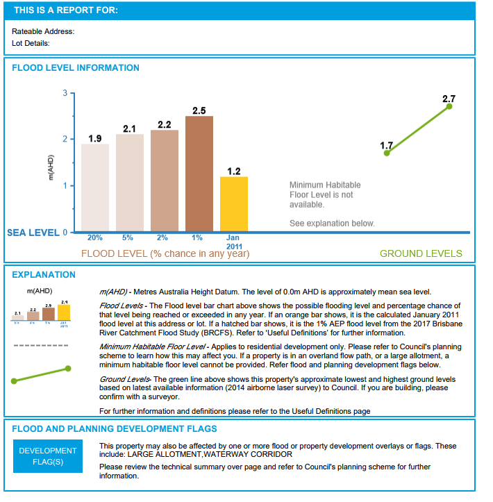
A FloodWise Property Report will provide information on what types of flooding a site may be subject to. An example of that report is shown below.
Example report page:
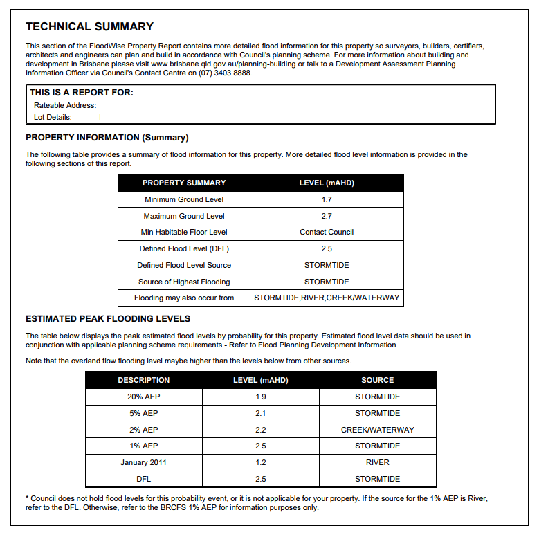
Example report page:
Brisbane River and Creek flooding
These types of flooding are fairly similar with the only distinctions being the source of the flooding and the speed of a flood event.
Brisbane River flooding is based on large rainfall within an expansive catchment area, so it can take days for flooding to be experienced. On the other hand, creek flooding is caused by rainfall over a much smaller catchment and can happen in a matter of hours and result in flash flooding. For example, a localised storm within the Bulimba Creek catchment will not necessarily result in a flood for the Brisbane River.
Brisbane City Council identifies the types of flooding on their mapping as they result from rainfall events in different catchments and also can have significant variations in the extent of flood inundation for a site.
A flood event in the Brisbane River for example can have impacts in creek and waterway systems running off it as these minor waterways have difficulty draining into the river due to the large volumes of water flushing through the River. In some instances Council has installed backflow prevention devices that stop backwater caused by river water rising up out of drains in areas such as New Farm and Bulimba. It should also be noted that these devices can not be relied upon when setting floor levels.
Storm tide
Storm tide flooding is caused when wind from a storm pushes the waters of the ocean or Moreton Bay towards land. This causes higher than normal sea levels and is particularly felt during high tidal flooding in coastal areas.
The State Planning Policy and City Plan 2014 mandate that storm tide is to be dealt with to flood proof development based on projected sea level rise until the year 2100. This is dealt with by the Coastal Hazard Overlay, which generally mandates a minimum finished habitable floor level of development of Reduced Level (RL) 3.6 metres (RL3.1 + 0.5m freeboard) Australian Height Datum (AHD) being a substantial increase above the previous standard of RL2.5 metres AHD. Coastal Hazard in many low lying areas is the most stringent standard to be applied however all types of flooding need to be assessed and planned for in any development proposal.
Overland flow
Overland flow path flooding is caused by water that runs across the ground after heavy rain. It happens quickly and is the most common type of flooding.
Because this type of flooding is very specific, and based on the actual rainfall catchment, Council do not have detailed hydraulic models on how this operates. In fact, mapping of most overland flow paths has only been available since 2014, but this is a useful tool in identifying where this type of flooding may occur.
A FloodWise Property Report will identify properties susceptible to this type of flooding but will not provide information on the depth, flow velocity or probability of these events. Where a site is subject to an overland flow path, a site specific hydraulic assessment is required and these can cost a few thousand dollars.
It is also important to note that the extent of an overland flow path shown on Council mapping may extend beyond the mapped area, which will be confirmed through the hydraulic assessment.
Where can I find out if my property floods?
You can find out what type(s) of flooding your property is subject to using the following free mapping and reporting services:
- http://cityplan2014maps.brisbane.qld.gov.au/CityPlan/
- http://floodinformation.brisbane.qld.gov.au/fio/
- http://floodinformation.brisbane.qld.gov.au/fio/floodwisesearch
The City Plan 2014 interactive maps will show the types of flood a site is subject to whilst the Flood Awareness Awareness Maps will show the likely extent of flooding for each event and probability of flooding for each year.
A FloodWise Property Report will consolidate all of this information and confirm the different heights of potential flooding for each probability of event. A 1% event simply means the probability of that even occurring in any single year is 1% or the equivalent of a 1 in 100 year risk (2% = 1 in 50 years, 5% = 1 in 20 years, 20% = 1 in 5 years). It is important to note that despite the probability of any given flood event, these could occur more regularly.
Why do I need to worry about flood?
Council have a duty of care and there are many considerations with respect to their position on flooding. These include, but are not limited to:
- protection of property
- public safety
- lessening demand on emergency services in a flood
- ensuring development does not cause greater flooding to others.
Where do I go for more information?
Consult Planning are able to identify the flood constraints applicable to a site and advise whether a hydraulic assessment needs to be undertaken and at what stage. Our Director Aaron Sweet has over 19 years of planning experience and has expertise dealing with flood prone sites. If you want his advice for your next project contact office@consultplanning.com.au. For detailed advice on flooding and overland flow you can contact Darren Rogers and his Team at Storm Water Consulting as they are experts in this field.
Image courtesy of David Jackmanson via Flickr
Disclaimer: While every effort has been made to provide accurate information, Consult Planning does not guarantee that this blog article is free from errors or omissions or is suitable for your intended use.